
The GEBCO_2026 Grid was published on 23rd April 2026 and is now available for download as a global file, tiles or for user-defined geographic areas.
Global ocean & land terrain models
GEBCO’s current gridded bathymetric data set, the GEBCO_2026 Grid, is a global terrain model for ocean and land, providing elevation data, in meters, on a 15 arc-second interval grid. It is accompanied by a Type Identifier (TID) Grid that gives information on the types of source data that the GEBCO_2026 Grid is based.
This release includes a version of the grid with under-ice topography/bathymetry information for Greenland and Antarctica.
- Download global coverage grids
- Download data for user-defined areas
- Multi-resolution grid product
- Access the GEBCO grid via OPeNDAP
More information about the grid, its terms of use and attribution. Provide feedback, tell us how you are using the grid.
GEBCO releases a new global grid every year, generally in July. Find out more about the grid generation process.
Download global coverage grids
The GEBCO_2026 Grid and TID Grid can be download as global files in netCDF format or a set of 8 tiles (each with an area of 90° x 90°), giving global coverage, in Esri ASCII raster and data GeoTiff formats. The data files are included in a zip file along with the data set documentation.
| GEBCO_2026 Grid (ice surface elevation) | netCDF (4 Gbytes, 7.0 Gbytes uncompressed) | Data GeoTiff (4 Gbytes, 7.2 Gbytes uncompressed) | Esri ASCII raster (4.8 Gbytes, 18.2 Gbytes uncompressed) |
| GEBCO_2026 Grid (sub-ice topo/bathy) | netCDF (4.1 Gbytes, 7.0 Gbytes uncompressed) | Data GeoTiff (4.1 Gbytes, 7.2 Gbytes uncompressed) | Esri ASCII raster (4.9 Gbytes, 18.2 Gbytes uncompressed) |
| GEBCO_2026 TID Grid | netCDF (94.4 Mbytes, 3.5 Gbytes uncompressed) | Data GeoTiff (91.7 Mbytes, 3.4 Gbytes uncompressed) | Esri ASCII raster (120.5 Mbytes, 9.6 Gbytes uncompressed) |
Please note that the size of the uncompressed files.
Download data for user-defined areas
Use our application to select and download data in netCDF, Esri ASCII raster and data GeoTiff formats.
PLEASE NOTE: On the 16th March we have released a new GEBCO download application. Please provide any feedback at gdacc@seabed2030.org

Multi-resolution grids
The global GEBCO grid is currently made available as a global 15 arc-second interval grid. However, in some regions, it is based on data at higher resolutions. To accommodate users who want access to higher resolution gridded bathymetry data, where it exists, a test multi-resolution grid product has been developed. This is now available through the new download application.
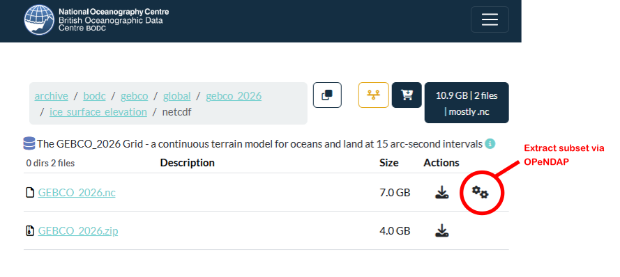
Access the GEBCO grid via OPeNDAP
GEBCO’s gridded data sets are now available for direct download from the Natural Environment Research Council's (NERC) Centre for Environmental Data Analysis (CEDA).
Through CEDA, GEBCO’s gridded data sets can also be accessed via OPeNDAP – allowing direct access to the data sets through a number of applications.
To access the GEBCO_2026 Grid via OPeNDAP – navigate to the directory that contains the netCDF data file for the gridded data set that you are interested in, for example, the ice surface elevation version of the grid, and click on the ‘extract subset’ icon to access the OPeNDAP Dataset Access Form and data set URL. The image below illustrates this.
Data set attribution for GEBCO_2026 Grid
If the data sets are used in a presentation or publication then we ask that you acknowledge the source. This should be of the form:
GEBCO Bathymetric Compilation Group 2026 (2026). The GEBCO_2026 Grid - a continuous terrain model for oceans and land at 15 arc-second intervals. doi:10.5285/4f68d5c7-45eb-f999-e063-7086abc036fa
Link: https://doi.org/10.5285/4f68d5c7-45eb-f999-e063-7086abc036fa
Terms of use
The GEBCO Grid is placed in the public domain and may be used free of charge. Use of the GEBCO Grid indicates that the user accepts the conditions of use and disclaimer information.
Data set errata and known issues
Although every care is taken during the development of the GEBCO bathymetric grids, errors can occasionally occur, and can be reported to the Seabed 2030 Global Centre ( gdacc@seabed2030.org ). Known issues can be viewed on our errata pages.
Type Identifier (TID) Grid
The TID grid identifies the type of source data that the corresponding grid cells in the GEBCO Grid are based on. Further information about the TID codes can be found in the accompanying documentation.
Find out more about the TID Grid from our StoryMap. English, Spanish and French language versions are available.


Note on vertical datum and GEBCO's grids
GEBCO's global elevation models are generated by the assimilation of heterogeneous data types assuming all of them to be referred to mean sea level. However, in some shallow water areas, the grids include data from sources having a vertical datum other than mean sea level. We are working to understand how best to fully assimilate these data.
Provide feedback
To help us improve our products and services, use our form to provide feedback on the GEBCO grid.