
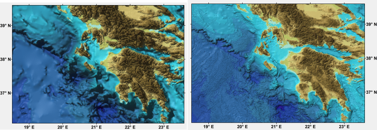
Comparison of images showing the shape of the seafloor for part of the Ionian Sea region off Greece as generated from the GEBCO One Minute Grid (left) and the GEBCO_2019 Grid (right)
GEBCO's first global bathymetric grid, the GEBCO One Minute Grid, was released in 2003. Since then a number of GEBCO grids have been published, with the latest release being available here.
GEBCO Data Catalogue
The full collection of GEBCO data releases are available for direct download through the Data Catalogue on the Natural Environment Research Council's (NERC) Centre for Environmental Data Analysis (CEDA) repository, available here.
This repository contains all releases, formats and documentation for the GEBCO Grid.
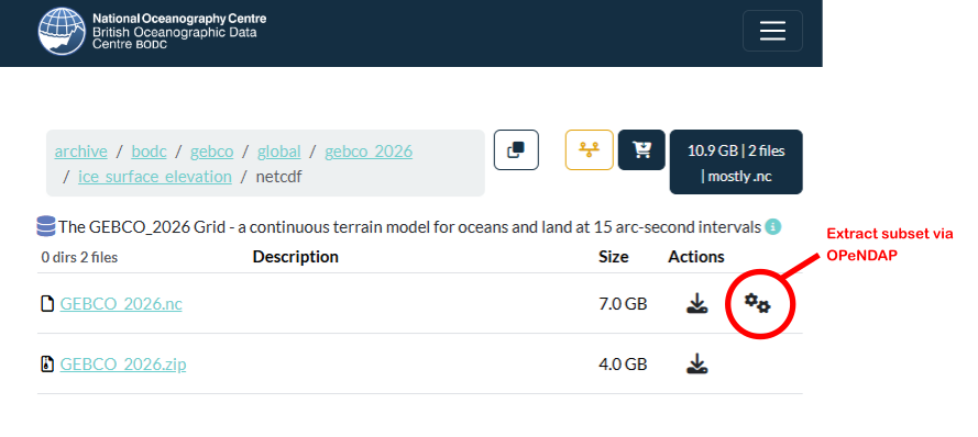
OPeNDAP
Through the GEBCO Data Catalogue, GEBCO’s gridded data sets can also be accessed via OPeNDAP – allowing direct access to the data sets through a number of applications. To access the GEBCO_2026 Grid via OPeNDAP – navigate to the directory that contains the netCDF data file for the gridded data set that you are interested in, for example, the ice surface elevation version of the grid, and click on the ‘extract subset’ icon to access the OPeNDAP Dataset Access Form and data set URL. The image below illustrates this:
Previous Releases
Find out about more about previous releases of the GEBCO grid and how to access the data sets.
| Grid name | Latest release year | Grid interval |
|---|---|---|
| GEBCO_2025 Grid | 2025 | 15 arc-seconds |
| GEBCO_2024 Grid | 2024 | 15 arc-seconds |
| GEBCO_2023 Grid | 2023 | 15 arc-seconds |
| GEBCO_2022 Grid | 2022 | 15 arc-seconds |
| GEBCO_2021 Grid | 2021 | 15 arc-seconds |
| GEBCO_2020 Grid | 2020 | 15 arc-seconds |
| GEBCO_2019 Grid | 2019 | 15 arc-seconds |
| GEBCO_2014 | 2015 | 30 arc-seconds |
| GEBCO One Minute Grid | 2008 | One arc-minute |
Previous releases
GEBCO_2025 Grid
A global grid at 15 arc-second intervals. Originally published in August 2025, it is the seventh GEBCO grid developed through the Nippon Foundation-GEBCO Seabed 2030 Project.
The grid uses as a ‘base’ Version 2.7 of the SRTM15+ data set [Tozer et al 2019] largely between latitudes of 50° South and 60° North. This data set is a fusion of land topography with measured and estimated seafloor topography. This is augmented with the gridded bathymetric data sets developed by the four Seabed 2030 Regional Centers.
The data set is accompanied by a Type Identifier Grid (TID). This data set identifies the type of source data that a grid cell is based on.
Access documentation and terms of use for the grid.
- Download GEBCO_2025 Grid - ice surface elevation version, available in NetCDF, Data GeoTIFF, and ESRI ASCII raster formats
- Download GEBCO_2025 Grid - sub-ice topography version, available in NetCDF, Data GeoTIFF, and ESRI ASCII raster formats
- Download GEBCO_2025 TID Grid, available in NetCDF, Data GeoTIFF, and ESRI ASCII raster formats
GEBCO_2024 Grid
A global grid at 15 arc-second intervals. Originally published in July 2024. This is the sixth GEBCO grid developed through the Nippon Foundation-GEBCO Seabed 2030 Project.
The grid uses as a ‘base’ Version 2.6 of the SRTM15+ data set, augmented with the gridded bathymetric data sets developed by the four Seabed 2030 Regional Centers.
The data set is accompanied by a Type Identifier Grid (TID). This data set identifies the type of source data that a grid cell is based on.
Access documentation and terms of use for the grid.
- Download GEBCO_2024 Grid - ice surface elevation version, available in NetCDF, Data GeoTIFF, and ESRI ASCII raster formats
- Download GEBCO_2024 Grid - sub-ice topography version, available in NetCDF, Data GeoTIFF, and ESRI ASCII raster formats
- Download GEBCO_2024 TID Grid, available in NetCDF, Data GeoTIFF, and ESRI ASCII raster formats
GEBCO_2023 Grid
A global grid at 15 arc-second intervals. Originally published in April 2023. This is the fifth GEBCO grid developed through the Nippon Foundation-GEBCO Seabed 2030 Project.
The grid uses as a ‘base’ Version 2.5.5 of the SRTM15+ data set, augmented with the gridded bathymetric data sets developed by the four Seabed 2030 Regional Centers.
The data set is accompanied by a Type Identifier Grid (TID). This data set identifies the type of source data that a grid cell is based on.
Access documentation and terms of use for the grid.
- Download GEBCO_2023 Grid - ice surface elevation version, available in NetCDF, Data GeoTIFF, and ESRI ASCII raster formats
- Download GEBCO_2023 Grid - sub-ice topography version, available in NetCDF, Data GeoTIFF, and ESRI ASCII raster formats
- Download GEBCO_2023 TID Grid, available in NetCDF, Data GeoTIFF, and ESRI ASCII raster formats
GEBCO_2022 Grid
A global grid at 15 arc-second intervals. Originally published in June 2022. This is the fourth GEBCO grid developed through the Nippon Foundation-GEBCO Seabed 2030 Project.
The grid uses as a ‘base’ Version 2.4 of the SRTM15+ data set, augmented with the gridded bathymetric data sets developed by the four Seabed 2030 Regional Centers.
The data set is accompanied by a Type Identifier Grid (TID). This data set identifies the type of source data that a grid cell is based on.
Access documentation and terms of use for the grid.
- Download GEBCO_2022 Grid - ice surface elevation version, available in NetCDF, Data GeoTIFF, and ESRI ASCII raster formats
- Download GEBCO_2022 Grid - sub-ice topography version, available in NetCDF, Data GeoTIFF, and ESRI ASCII raster formats
- Download GEBCO_2022 TID Grid, available in NetCDF, Data GeoTIFF, and ESRI ASCII raster formats
GEBCO_2021 Grid
A global grid at 15 arc-second intervals. Originally published in July 2021. This is the third GEBCO grid developed through the Nippon Foundation-GEBCO Seabed 2030 Project.
The grid uses as a ‘base’ Version 2.2 of the SRTM15+ data set, augmented with the gridded bathymetric data sets developed by the four Seabed 2030 Regional Centers.
The data set is accompanied by a Type Identifier Grid (TID). This data set identifies the type of source data that a grid cell is based on.
Access documentation and terms of use for the grid.
- Download GEBCO_2021 Grid - ice surface elevation version, available in NetCDF, Data GeoTIFF, and ESRI ASCII raster formats
- Download GEBCO_2021 Grid - sub-ice topography version, available in NetCDF, Data GeoTIFF, and ESRI ASCII raster formats
- Download GEBCO_2021 TID Grid, available in NetCDF, Data GeoTIFF, and ESRI ASCII raster formats
Access errata information for the GEBCO_2021 Grid
GEBCO_2020 Grid
A global grid at 15 arc-second intervals. Originally published in May 2020. This is the second GEBCO grid developed through the Nippon Foundation-GEBCO Seabed 2030 Project.
The grid uses as a ‘base’ Version 2 of the SRTM15+ data set (Tozer et al, 2019), augmented with the gridded bathymetric data sets developed by the four Seabed 2030 Regional Centers.
The data set is accompanied by a Type Identifier Grid (TID). This data set identifies the type of source data that a grid cell is based on.
Access documentation and terms of use for the grid.
- Download GEBCO_2020 Grid - ice surface elevation version, available in NetCDF format
- Download GEBCO_2020 TID Grid, available in NetCDF, Data GeoTIFF, and ESRI ASCII raster formats
Access errata information for the GEBCO_2020 Grid
GEBCO_2019 Grid
A global grid at 15 arc-second intervals. Originally published in April 2019. This is the first GEBCO grid developed through the Nippon Foundation-GEBCO Seabed 2030 Project. This is a collaborative project between the Nippon Foundation of Japan and GEBCO. The Seabed 2030 Project aims to bring together all available bathymetric data to produce the definitive map of the world ocean floor and make it available to all.
The grid uses as a ‘base’ Version 1 of the SRTM15+ data set (Olson et al, 2014). This data set is a fusion of land topography with measured and estimated seafloor topography. It is largely based on version 11 of SRTM30+ (Becker et al, 2009; Sandwell et al, 2014), augmented with the gridded bathymetric data sets developed by the four Seabed 2030 Regional Centers. The published data were recalculated on a cell-registered grid for use by GEBCO.
When first published, the grid was accompanied by a Source Identifier Grid (SID). This indicates if the corresponding cells in the GEBCO_2019 Grid are based on soundings, pre-generated grids or interpolation. The SID grid was replaced by a Type Identifier Grid (TID) in December 2019. The TID grid identifies the type of source data that a grid cell is based on. Both the SID and TID grids are available to download.
Access documentation and terms of use for the grid.
- Download GEBCO_2019 Grid - ice surface elevation version, available in NetCDF format
- Download GEBCO_2019 TID Grid, available in NetCDF, Data GeoTIFF, and ESRI ASCII raster formats
- Download the GEBCO_2019 Source Identifier (SID) Grid, available in NetCDF format
Access errata information for the GEBCO_2019 Grid
GEBCO_2014 Grid
A global grid at 30 arc-second intervals. Originally published in 2014, last updated in April 2015. The data set is largely based on a database of ship-track soundings with interpolation between soundings guided by satellite-derived gravity data. Where they improve on this model, data sets generated from other methods are included.
The grid is accompanied by a Source Identifier Grid (SID). This indicates if the corresponding cells in the GEBCO_2014 Grid are based on soundings, pre-generated grids or interpolation.
Access documentation and terms of use for the grid.
- Download GEBCO_2014 Grid, 2015 version, available in NetCDF format
- Download GEBCO_2014 SID Grid, 2015 version available in NetCDF format
Access errata information for the GEBCO_2014 Grid
GEBCO One Minute Grid
A global grid at one arc-minute intervals. Originally published in 2003, last updated in 2008. The data set is largely based on bathymetric contours from the Centenary Edition of the GEBCO Digital Atlas.
Access documentation and terms of use for the grid.
Download GEBCO One Minute Grid, 2008 version, available in NetCDF format
Please note that these data sets are superseded by GEBCO's latest bathymetric grid.